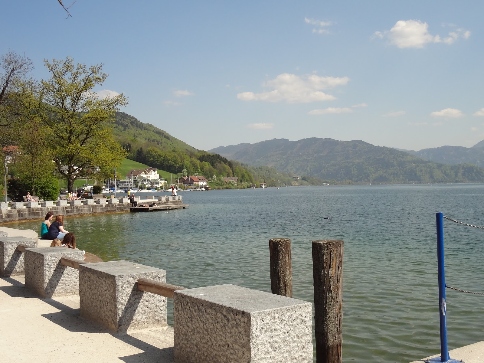
I've been over the injury I picked up on my "Tour de Austria" for quite a while, but a combination of the strange June weather in Munich and not having anything to train for I haven't really done much cycling around Munich. I have cycled to work quite a bit, which is 22 miles per day, so I have been keeping up my fitness and thought I would test myself.
There are 2 big lakes around Munich, one of which I have been to and talked about in a previous post is Starnberger, the other is Ammersee. I thought this time I would try and go to Ammersee - although it is further away and I hadn't done a ride like that in a while.
The ride was slower than I would have liked at the start because I had to get through the city, but eventually the traffic lights went away and managed to pick up some speed. Unfortunately it didn't take long to realize that I wasn't strong enough to make it all the way, so when I saw a sign pointing to a different lake that I didn't even realize was there I went for that one instead. That way I knew I would be able to go there, look around, lie in the sun and still be able to ride back home.
I was surprised to find that this lake was not just one lake, but 2 split by a fairly narrow path with space to lie on either side.
I lay down for about half an hour reading my book (Magnificat by Julian May) and ate lunch in the sun, this place must be really popular because there was people all the way round both lakes. I decided that if I were to train for a Triathlon then this is where I would go for the swimming and running parts.
I still had plenty of energy to get home but I could see that it was going to rain soon and decided to shorten my day a bit and go part of the way back by train. I was going to head for the nearest S-Bahn, but when the rain fell it felt really nice. It was that kind of warm refreshing rain, which if anything made cycling more comfortable, so I decided to head for Marienplatz (Munich Centre) and take the U-Bahn home. This is 10 miles (16k) from that lake, which made my daily riding at a nice round 30 miles.
The warm rain stopped and turned instead to a downpour, which wasn't so nice to cycle in, and when I got back into Munich I lost my second "cat-life". I realize now that I didn't write about that but this is basically what happened. I was trying for a 10 mile PB on the way home from work and in the last mile really gave it my all, on a road. The notification that I had finished 10 miles came and I slowed down and stopped concentrating. Then I rode off to the side off the road (which had a dip) and I lost control. I knew the bike was going to go down so I somehow dumped over it and landed on my feet, going at over 20 mph at the time! That is what I call losing my first "cat-life"
So this day I lost my second. When I got to the city centre I started heading for Odeonsplatz, which is the easiest station for me to travel from as it doesn't need cycling into the busiest part of the city. On the way there there is some tram lines. Normally I handle these just fine, riding over them with a sufficient angle NOT to fall in the line with my wheel, but not this time! I went into the tram line, couldn't get out and fell, but again landed on my feet! Seriously I don't know how I am doing it, but I am glad not to have had an injury!
Today I rode 31 miles in 2h 20m.
The workouts were split into 2, you can find them here and here.
Viel Spaß homies!
My Philosophy
"Don't tell me the sky's the limit when we have footsteps on the moon!"
Showing posts with label lake. Show all posts
Sunday, 17 July 2011
Tuesday, 3 May 2011
Tour de Austria: Day 3 (Moon Lake)
During the previous days' grueling toil I decided that I would make this day mostly a rest day and for exploring the extremely pretty lakeside town of Mondsee (literal translation Moon Lake).
First though a word on the previous night, after checking into the hotel and doing a little check on how messed up my body was I called my parents. I started by saying "Firstly, im ok and checked into the hotel, but im such a fucking idiot!" and then I explained the story explained in the 3 previous posts. Afterwards I managed to find the energy to go downstairs for dinner. It was the best schnitzel I'd ever had, and well earned :)
I went to bed and slept like a log for I have no idea how long.
After loading up on breakfast I decided to have a walk around town, it was more of a retirement town than anything else. But still very pretty. At one point I was walking towards the hill I climbed, when I realized what it was I was laughing so hard I had to sit down.
As today was to be a rest day I thought I would have a massage as well, as a great reward for my heavily punished legs. It took me a while to find a masseur but once I did she turned out to be formerly of the Austrian Olympic massage team, so it was a good one! The thing was that she only spoke German, so it was a big test, but as I managed to not get my neck broken I guess I did OK.
I didn't do much this day other than walk, stretch my legs and eat ice cream. I spent most of my time trying to even out my stupidly uneven tan lines by the lake and reading my book.
Hope you like the pics of this place, it was awesome and I'm definitely going to come back on my next trip!
Viel Spaß homies!
First though a word on the previous night, after checking into the hotel and doing a little check on how messed up my body was I called my parents. I started by saying "Firstly, im ok and checked into the hotel, but im such a fucking idiot!" and then I explained the story explained in the 3 previous posts. Afterwards I managed to find the energy to go downstairs for dinner. It was the best schnitzel I'd ever had, and well earned :)
| You can't see it in the pic but there was more salad than chips! |
After loading up on breakfast I decided to have a walk around town, it was more of a retirement town than anything else. But still very pretty. At one point I was walking towards the hill I climbed, when I realized what it was I was laughing so hard I had to sit down.
As today was to be a rest day I thought I would have a massage as well, as a great reward for my heavily punished legs. It took me a while to find a masseur but once I did she turned out to be formerly of the Austrian Olympic massage team, so it was a good one! The thing was that she only spoke German, so it was a big test, but as I managed to not get my neck broken I guess I did OK.
I didn't do much this day other than walk, stretch my legs and eat ice cream. I spent most of my time trying to even out my stupidly uneven tan lines by the lake and reading my book.
| Watching the sunset reading one of my favourite books in the world (Jack The Bodiless) |
Viel Spaß homies!
Saturday, 30 April 2011
Tour de Austria: The Forest
The result of my aforementioned stupidity was that I would have a long grueling journey up a hill/forest. This would last 3 hours and occurred after nearly 5 hours of cycling, stupid, stupid me!
At the end of the last post I had stopped for a breather at what I thought would be the top of the hill, suitably pleased with my efforts I plodded along through a farm. One of the workers at the farm saw me and said "Servus" (Hello) but was looking at me a bit funny. I ignored that and plodded along, I could see a down hill, very steep so I unleashed and got some major speed.
Then I realised why the guy was looking at me funny, I was heading for a dead end. Yep, the track just ended. This was pretty dangerous because the hill was still steep. I stopped and swore really loudly (in English) and heard an echo. More pain was endured getting back up this hill that had been so enjoyable going down. I swore a couple more times on the way up.
When I got back to the farm I asked the guy how to get to Mondsee (where my hotel was), he told me the way (in German) and refilled my empty water bottles (also very stupid of me not carrying more!). He said NOT to turn towards the church, but after checking Google the next day that way would have indeed been quicker and avoided the highest point of the hill.
I explained in my last post that my map described height or difficulty of a hill with a number. That day I had done a couple of 3's and 2's but what I was facing after not turning towards the church was a 7!!! And this was with a bumm knee as well so riding was both slow and painful - very poor for morale!
The terrain was very level here for about 10 minutes until I was greeted with another hill. I cycled up all the way of this one but when I reached the top my quadriceps were actually twitching and quite badly so I stopped again and stretched. I was in a lot of pain here.
After an hour of switching between walking and riding up the hill I saw something picture worthy, which was the lake I should have been cycling alongside lol.
This doesn't really show just how high up I was, maybe this one does...
At this point I realised that it was quite late and wasn't sure if the hotel had a deadline for people checking in, so I called them up but had no answer. Well, the only thing to do is carry on right? So I did, and finally I could see the top! And this time it was the real top. It was blocked by one of those level pole barriers to stop cars, one one side was a cliff and the other the hill continued so I couldn't get my bike round it or under it, so it had to go over.
At the top I saw a sign for Mondsee, but the problem was that it was a hiking sign. I looked at the trail and it was indeed unsuitable for a bike, not even a top of the line mountain bike. I swore again. What got me this far was the belief that every stride up hill would mean a nice downhill stretch, but instead I had to practically carry my bile and gear down the hill, using more energy than going up did!
At one point the toil became too great and I had to rest, I put my bike down and sat on a log and looked up at the sky for a while. Suddenly I heard a really loud snort from an animal behind me. Startled, I looked behind me and behind a (low) fence there was about 15 stags, all of them staring at me. I wanted a picture but I wanted more to get the hell out of there! So on I moved.
This was all down hill but the ground had been minced by a tractor at some point and with a cliff on my left I deemed it unsuitable for riding other than when it was good enough, which was no very often at all. On one of these rare occasions that I was on the bike I got the fright of my life!
A deer came running from my right down the hill, I was so shocked that I nearly fell off, I hope that if I did fall off I would have the sense to fall right instead of left, otherwise that would have been the end. That adrenalin was used to get me further down the hill, which was becoming more and more cyclable ground. I even saw a nice looking cycle path going down hill, I prayed that I would be on there soon. Something even better than that happened!
I saw that the path I was following turned a corner and around this corner was the most amazing downhill stretch I had ever been on, but I also saw a truly breathtaking view (and at this point I hadn't much breath left to give!).
Unfortunately this picture doesn't really do the view justice and I only took one, so keen was I to get to Mondsee that I got straight back on my bike and rode like a bat out of hell down the best downhill cycle path I have ever been on. The smile on my face had returned.
Total Cycling distance: 68 miles (110km)
Total Calories (estimate): 4500
Highest hill climbed: 1050m
Pain factor: very high!
Viel Spaß homies!
At the end of the last post I had stopped for a breather at what I thought would be the top of the hill, suitably pleased with my efforts I plodded along through a farm. One of the workers at the farm saw me and said "Servus" (Hello) but was looking at me a bit funny. I ignored that and plodded along, I could see a down hill, very steep so I unleashed and got some major speed.
Then I realised why the guy was looking at me funny, I was heading for a dead end. Yep, the track just ended. This was pretty dangerous because the hill was still steep. I stopped and swore really loudly (in English) and heard an echo. More pain was endured getting back up this hill that had been so enjoyable going down. I swore a couple more times on the way up.
When I got back to the farm I asked the guy how to get to Mondsee (where my hotel was), he told me the way (in German) and refilled my empty water bottles (also very stupid of me not carrying more!). He said NOT to turn towards the church, but after checking Google the next day that way would have indeed been quicker and avoided the highest point of the hill.
I explained in my last post that my map described height or difficulty of a hill with a number. That day I had done a couple of 3's and 2's but what I was facing after not turning towards the church was a 7!!! And this was with a bumm knee as well so riding was both slow and painful - very poor for morale!
The terrain was very level here for about 10 minutes until I was greeted with another hill. I cycled up all the way of this one but when I reached the top my quadriceps were actually twitching and quite badly so I stopped again and stretched. I was in a lot of pain here.
After an hour of switching between walking and riding up the hill I saw something picture worthy, which was the lake I should have been cycling alongside lol.
This doesn't really show just how high up I was, maybe this one does...
At this point I realised that it was quite late and wasn't sure if the hotel had a deadline for people checking in, so I called them up but had no answer. Well, the only thing to do is carry on right? So I did, and finally I could see the top! And this time it was the real top. It was blocked by one of those level pole barriers to stop cars, one one side was a cliff and the other the hill continued so I couldn't get my bike round it or under it, so it had to go over.
At the top I saw a sign for Mondsee, but the problem was that it was a hiking sign. I looked at the trail and it was indeed unsuitable for a bike, not even a top of the line mountain bike. I swore again. What got me this far was the belief that every stride up hill would mean a nice downhill stretch, but instead I had to practically carry my bile and gear down the hill, using more energy than going up did!
![]() |
| The reward for me getting to the top of the hill was to work harder getting down! |
At one point the toil became too great and I had to rest, I put my bike down and sat on a log and looked up at the sky for a while. Suddenly I heard a really loud snort from an animal behind me. Startled, I looked behind me and behind a (low) fence there was about 15 stags, all of them staring at me. I wanted a picture but I wanted more to get the hell out of there! So on I moved.
This was all down hill but the ground had been minced by a tractor at some point and with a cliff on my left I deemed it unsuitable for riding other than when it was good enough, which was no very often at all. On one of these rare occasions that I was on the bike I got the fright of my life!
A deer came running from my right down the hill, I was so shocked that I nearly fell off, I hope that if I did fall off I would have the sense to fall right instead of left, otherwise that would have been the end. That adrenalin was used to get me further down the hill, which was becoming more and more cyclable ground. I even saw a nice looking cycle path going down hill, I prayed that I would be on there soon. Something even better than that happened!
I saw that the path I was following turned a corner and around this corner was the most amazing downhill stretch I had ever been on, but I also saw a truly breathtaking view (and at this point I hadn't much breath left to give!).
Unfortunately this picture doesn't really do the view justice and I only took one, so keen was I to get to Mondsee that I got straight back on my bike and rode like a bat out of hell down the best downhill cycle path I have ever been on. The smile on my face had returned.
Total Cycling distance: 68 miles (110km)
Total Calories (estimate): 4500
Highest hill climbed: 1050m
Pain factor: very high!
Viel Spaß homies!
Thursday, 28 April 2011
Tour de Austria: Day 2 (Part 2)
The stupid parts
I mentioned already that the specific cycling routes were marked and sign posted, the problem is when these are missing at key junctions. This happened shortly after the events of my last post but with happy results. The route I would have taken would have skipped one of the lakes in the area, it was only a small 7 mile diversion but if I hadn't made it I would have missed out on this view!
And to prove I was actually there instead of taking pictures from Google :-)
I went further around the lake, which curved up hill and I noticed my energy levels were getting low and stopped here for another bite to eat and drink. At this point I was very confident of where I was.
I don't have a clue how it happened but the next time I looked at the map I was in a completely different place to where I thought, and heading South instead if North. It turns out that there was a point where I was following 2 routes and turned off following the wrong one. I had 2 choices; head back north back to the originally intended route or carry on South and go another way round to my destination town. The first if my major incorrect decisions. Hindsight is a wonderful thing.
This route would add an extra lake and wasn't much further so I went for it. The map I was using had different colours for the different routes but it also had a separate colour for commonly used Radwegs but not part of an official route. I saw one of these near that would be a short cut to the lake. Remember what the hobbits said about short cuts? Yep they lead to long delays. This time is no exception.
The map also graded the difficulty of the hills with numbers. This route had a 3 and a 1 and then down to the normal ground level by the lake. I had already done a 3 and a 4 that day. One more couldn't hurt could it? If you hadn't guessed that was my second stupid decision.
I wanted to be able to tell you that none of the hills beat me, but I had to walk up some of the first part of the hill; but this was my fifth hour of hill riding... My ambition got the better of me and I was feeling a pain in my right knee when pushing hard. That would prove a problem over the next couple of days. The hill seemed never ending, weaving round and round, it didn't take long for me to have to walk up all the time. This was also pretty tough.
Finally it levelled out and there was a bench at the top! FTW! I thought I had passed the worst of it so had a little rest and was looking forward to some nice sweeping down hills that would make the toil up the hill worth while. Little did I know that this would be a middle plateau, with much a much higher one to come. If there was a way down I couldn't find it. From then for the next hour it would be a long toil up hill. Poor decision number 3 was not turning back, it would still have been quicker.
To give you an idea of where I was here is a Google satellite view of where I was.
Red is the actual route that I went, through a hill/forest. In blue is the official cycle path, without any tough hills. At this point in the story I was where the X is, which is about 600m up, only 450 to go!
The craziness that happened in the forest will be explained in the next post! Stay tuned.
Viel Spaß homies!
I mentioned already that the specific cycling routes were marked and sign posted, the problem is when these are missing at key junctions. This happened shortly after the events of my last post but with happy results. The route I would have taken would have skipped one of the lakes in the area, it was only a small 7 mile diversion but if I hadn't made it I would have missed out on this view!
And to prove I was actually there instead of taking pictures from Google :-)
I went further around the lake, which curved up hill and I noticed my energy levels were getting low and stopped here for another bite to eat and drink. At this point I was very confident of where I was.
I don't have a clue how it happened but the next time I looked at the map I was in a completely different place to where I thought, and heading South instead if North. It turns out that there was a point where I was following 2 routes and turned off following the wrong one. I had 2 choices; head back north back to the originally intended route or carry on South and go another way round to my destination town. The first if my major incorrect decisions. Hindsight is a wonderful thing.
This route would add an extra lake and wasn't much further so I went for it. The map I was using had different colours for the different routes but it also had a separate colour for commonly used Radwegs but not part of an official route. I saw one of these near that would be a short cut to the lake. Remember what the hobbits said about short cuts? Yep they lead to long delays. This time is no exception.
The map also graded the difficulty of the hills with numbers. This route had a 3 and a 1 and then down to the normal ground level by the lake. I had already done a 3 and a 4 that day. One more couldn't hurt could it? If you hadn't guessed that was my second stupid decision.
I wanted to be able to tell you that none of the hills beat me, but I had to walk up some of the first part of the hill; but this was my fifth hour of hill riding... My ambition got the better of me and I was feeling a pain in my right knee when pushing hard. That would prove a problem over the next couple of days. The hill seemed never ending, weaving round and round, it didn't take long for me to have to walk up all the time. This was also pretty tough.
Finally it levelled out and there was a bench at the top! FTW! I thought I had passed the worst of it so had a little rest and was looking forward to some nice sweeping down hills that would make the toil up the hill worth while. Little did I know that this would be a middle plateau, with much a much higher one to come. If there was a way down I couldn't find it. From then for the next hour it would be a long toil up hill. Poor decision number 3 was not turning back, it would still have been quicker.
To give you an idea of where I was here is a Google satellite view of where I was.
The craziness that happened in the forest will be explained in the next post! Stay tuned.
Viel Spaß homies!
Sunday, 24 April 2011
Tour de Austria: Day 2
This is quite a fun story to tell, I don't mind telling of my stupidity because it turned out to be so rewarding. I had planned about 50 miles of riding, weaving in and out of lakes and towns, it's not exactly that far but with the hilly terrain it could have been tough.

I had a quick consult of my map and it indicated that I was only 5 miles from the first lake of the day, so after an apple (you can call that either third breakfast or first lunch). The time before reaching the lake went by really quick and so this view opened up.
The funnier view though was when I looked down at my arm - if you remember from my last cycling post I had a pretty bad tan line on my arm, this time I decided to go in a vest top and try to even it out, by only putting sun cream on the existing plan. Genius. the funny part was that a lot of bugs had been committing suicide against me while I was cycling, and a lot of them got caught in my sun-creamy arm.
To start with I had to find the Radweg (Cycling trail) from Salzburg north to Obertrumer See, which as it turned out I hadn't and I spent an hour going not quite the right direction, but it was good enough so not much time was wasted. The trail I took was nearly straight up hill for a while, until I came to my favourite kind of place for cycling - the rolling up and down hills. I saw this view and thought it was as good a place as any to stop for lunch.
I hoped to god that I wouldn't have to climb that hill... I did
Even funnier was when the flies would fly into my glasses, so I would see a squished blob on my lenses. When I got up to high speeds they would quite comically slide off, like in the cartoons.
When I was cycling around this first lake I saw something that was a little surprising; a guy that looked like he was in his 80s was also cycling around the lake, after cycling up a light hill I stopped to take a couple more pictures and he caught up with me and said "Servus! Los Gehts!" (Hi! Off we go!). I laughed. I doubt that would have happened in any other country (except Germany maybe).
This was a very beautiful place, but there is a better picture of it further down (or up) the trail. I stopped in a town called Mattsee, which lies between 2 lakes. I expected that there would be a pub or something to stop for a Radler, but amazingly there wasn't one (well there was one but not open till 5) suitably disappointed but still craving the refreshing shandy I stopped off at a pub in the town centre.
The waiter here was very friendly and kindly gave me directions to the next Radweg. The only problem was I asked in German and didn't completely understand the response - needless to say I got lost shortly after this. To get out of the town is quite a steep uphill, but I came to a main junction, where both directions were main roads with 100kmh speed limits, so I assumed I went too far and went back down the hill. There was no other route.
Normally there are signs that point cyclists in the direction of the track. This is one of the many critical times where there wasn't one, and I cursed my German for not being able to understand what the guy said. Straight or left. I tried straight, 100m later there was a left turn, which I knew was the direction I needed to go, so I went that way (the other way was a dual carriageway). After not too long this way seemed to be nearly vertical, at this point my legs were getting weary so i gave up and went back down.
As Spok says "Once you have eliminated the impossible, whatever remains, however improbable must be the truth". Having eliminated the impossible I went along the 100kph single carriageway. At first glance it didn't seem so steep, but it got very steep and I could see that the top was very far away, my legs were weary still and I could see a parking place to stop and catch my breath. I am glad that I did because what I saw took my breath away.
I summoned the energy to have another go up the hill. As it was a very fast road I didn't want to stop on the road so I resolved to make it all the way up without stopping. I succeeded but was already feeling that I had bit off more than I could chew, but there was nothing for it - I had to make it to Mondsee to make my reservation in the nice hotel.
I can see that this post is already getting a bit long, so I think it would be best to split this day into several posts. Stay tuned for the REALLY stupid parts :)
Viel Spaß homies!
Tuesday, 19 April 2011
Today's Office
I have put up a couple of "Today's office" pictures on Facebook but hadn't been anywhere for work in a while. For those that don't know the story; as a "field tester" for Sony Ericsson I test their phones out in the "field". Unfortunately this can't be a beer garden kind of field, but testing handover conditions on networks.
The Munich office of Sony Ericsson is also responsible for Switzerland and Austria. Sorry or the boring factiods but its important to explain WHY I was where I was today, which is in Switzerland testing an issue found by a Swiss network. This is just another amazing thing about my job, because I can have my lunch break in a place like this!
Aston Martin flying around the same place we were testing
This is Bodensee, a massive lake of which Germany, Austria and Switzerland share a boundary. A really beautiful place to go to work!
If you've noticed an improvement in picture quality then well done and thank you! I got a new camera so I can show yo much better shots of the Austrian Lakes, where I go tomorrow morning! Stay tuned for that!
Viel Spaß homies!
Monday, 11 April 2011
Starnberger See

When I got the offer to work in Munich my first thought was "Awesome OKTOBERFEST!!!" but that was shortly followed by "I wonder if there will be some cool cycling around there?". A quick google maps search of the surrounding area made me I think more excited than Oktoberfest.
In my eagerness to go out and explore by bike I booked a cycling holiday to the Austrian Lakes (just east of Salzburg) in which I will be cycling between 50 and 80 kilometers (30 - 50 miles) for 3 days in a row. It had been a while since I went for a long bike ride so I wasn't sure how my beer and pastry filled body would cope with that kind of distance now so I planned a little excursion to test my limits.
The new bike will be covered in more detail in another post but here it is:
Trek 7500
Picking a destination was actually really easy. If you go to google maps and have a quick look at the surrounding area of Munich you will see a pair of really big lakes to the South West. I just knew that that destination would be an awesome place to end up and have a couple of beers by the shore. It didn't disappoint, but I was so surprised at how utterly amazing the ride there was! This is the route I chose (initially):

Originally the route would have been about 40km
The first part of my route I have done many times before as it is from Garching (north of Munich) and to the centre of Munich, that is the first part of my route to work when I can be bothered to ride in. Cycling in the city centre of Munich deserves its own post, so one will be prepared for that and I will skip ahead about an hour and a half to when I was south of the main part of the city and I could really start picking up some speed before the next set of lights. Here I was riding parallel with the river Isar.
At this point my energy levels were running a little low so I decided to find a good spot for lunch. After a ride through a very tempting beer garden I went a short way into a forest in the direction of the river. I knew that if I went to the beer garden that would be the end of my trip, and there was so far to go! So I went to the forest, waited until I had a view of the river and stopped for lunch.


It's hard to see but the river is down there!
which came into view a couple of times, but in order to ride alongside it directly I would have had to go down a very steep slope (like -15), which I normally don't see as a problem but that early in the bike ride I didn't want to have to cycle back UP that slope so I gave it a miss.
That turned out to be an incredibly good decision considering what came next completely out of the blue. After riding through a town I carried on straight but there was a short but incredibly steep hill just after it, all there was for it was to just get in a lower gear and ride until the burn in your legs in nearly unbearable, shift down and repeat. I didn't realise it at the time but the reward for getting up that hill was well worth the pain endured:
I got my first good view of the Alps (not from a car), I could feel my legs complain slightly after the hill so I stopped to take the picture and look around a bit then carried on, spurred and more energetic than ever with seeing the mountains. At a roundabout I saw a sign saying Innsbruck 109km, which gave me an idea - more on that another time I think.
I could not believe how motivational and inspirational it was cycling towards the Alps, I could feel them just get slightly bigger as I felt like I was hurtling towards them. It was also awesome that this part of the route was mostly straight cycle tracks and some rolling hills. On the rolling hills it was so easy to pick up speed that I was mostly going over 20mph UP the hills and a reasonable speed of 30mph on one of the downhill stretches here. Love it!
In fact I got so distracted with the speed and the Alps getting bigger (at least I thought) that I missed my turning! I went a full 2 towns further that I originally intended, but at that point I didn't care, I was able to eat up a lot of miles during this stretch. I even felt like extending the ride even further than my diversion forced. Changed my mind pretty quickly after a very short very steep hill, that wasn't exactly what I needed after 2 hours of riding and more than ever I was looking forward to a nice cold beer by the lake. On the way to the next town I felt like I was cycling through treacle so I stopped for 10 minutes for a drink and some more energy replenishment. This is what that place looked like:


The lake I was heading for was about 10k away from there and I decided I would have a Radler (lager shandy) when I got my first sight of the lake. When I saw it there was a really steep downhill to get there. I really wish I stopped to take a picture of this view and downhill section but I got carried away and just flew down hill at a 39mph. Was a little scared but the awesome disk brakes of my bike soon alleviated those fears.

The next track was a big challenge for my bike, the kind of situation where a mountain bike would have been at home but not quite my hybrid. Ah well, after a bumpy ride I came to this:

That sign means there is a Hacker-Pschorr beer garden 300m up that slope. It's hard to tell from the picture just how steep the slope is but it was VERY steep. Spurred on by the immanent appearance of a beer garden I started to make my way up the hill. By far the steepest of the day and guess what, didn't make it :P Got about half way before I stopped and had to walk it, which was hard enough!
I was disappointed that this beer garden did not at all face the lake, so I did not take a picture, but I had got my hopes up for the Radler that I sat and had that and a lot of water.
The last part of the journey was thankfully quite easy and before I knew it I was sitting here watching over the lake and eating I would say a well deserved ice cream.
In fact I got so distracted with the speed and the Alps getting bigger (at least I thought) that I missed my turning! I went a full 2 towns further that I originally intended, but at that point I didn't care, I was able to eat up a lot of miles during this stretch. I even felt like extending the ride even further than my diversion forced. Changed my mind pretty quickly after a very short very steep hill, that wasn't exactly what I needed after 2 hours of riding and more than ever I was looking forward to a nice cold beer by the lake. On the way to the next town I felt like I was cycling through treacle so I stopped for 10 minutes for a drink and some more energy replenishment. This is what that place looked like:


The lake I was heading for was about 10k away from there and I decided I would have a Radler (lager shandy) when I got my first sight of the lake. When I saw it there was a really steep downhill to get there. I really wish I stopped to take a picture of this view and downhill section but I got carried away and just flew down hill at a 39mph. Was a little scared but the awesome disk brakes of my bike soon alleviated those fears.

no beer garden down here :(
The next track was a big challenge for my bike, the kind of situation where a mountain bike would have been at home but not quite my hybrid. Ah well, after a bumpy ride I came to this:

That sign means there is a Hacker-Pschorr beer garden 300m up that slope. It's hard to tell from the picture just how steep the slope is but it was VERY steep. Spurred on by the immanent appearance of a beer garden I started to make my way up the hill. By far the steepest of the day and guess what, didn't make it :P Got about half way before I stopped and had to walk it, which was hard enough!
I was disappointed that this beer garden did not at all face the lake, so I did not take a picture, but I had got my hopes up for the Radler that I sat and had that and a lot of water.
The last part of the journey was thankfully quite easy and before I knew it I was sitting here watching over the lake and eating I would say a well deserved ice cream.
So the stats for todays ride were:
Distance: 68.6km (41.5 miles)
Time: 3h 30 mins
Average Speed: 19.7kph (12.3 mph)
Max Speed: 68.3 (42.4 mph)
Calories: 3128
Check out the full stats here: http://www.endomondo.com/workouts/rsmZSAak84U
Feel free to friend me on Endomondo if you are also doing running/cycling!
Check out the full stats here: http://www.endomondo.com/worko
Feel free to friend me on Endomondo if you are also doing running/cycling!
Not a bad ride! Comments are always welcome, and congratulations for making it all the way through the long tedious blog :)
Viel Spaß homies!
Subscribe to:
Posts (Atom)